
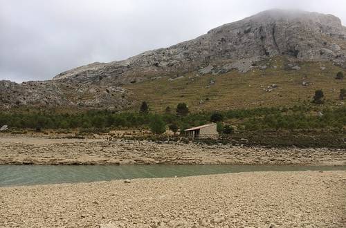
Majorca is the largest of the Balearic Islands and has a diverse landscape. The island's highest elevation is the Puig Major in the Serra de Tramuntana.
The island, approximately 78 kilometres wide and just under 98 kilometres long, has a 550-kilometre coastline, numerous smaller bays and an approximately 20-kilometre-wide mountain range – the Serra de Tramuntana. This runs along the northwestern cliff coast to the well-known „Cap de Formentor“and takes up around a quarter of the entire island's surface area.
The Puig Major and the Tramuntana Mountains
The Tramuntana has several peaks that are over 1,000 metres high. By far the highest peak is named Puig Major. The highest mountain in Mallorca is located in the northeast of Sóller and has a total height of 1.445 metres.Literally translated, the name means „great mountain.“ Geographically, the mountain is part of the tiny municipality of Escorca, and its summit is a restricted military zone. It is an important part of the Tramuntana Mountains and lies directly in the „Serra de Son Torella“. The mountain consists of a compact mountain massif and has several secondary peaks in addition to the highest summit. The most famous secondary peak bears the name „Penyal des Migdia“ (the Midday Peak) and is located in the southwest of the island's highest point. The Midday Peak is 1,398 metres high and thus a little higher than the island's second-highest (1,365 metres) mountain, „Puig de Massanella“. With its visually impressive cliff face, the Midday Peak overlooks the Fornalutx valley. From the small town of Sóller you can best view the Penyal des Migdia. At the summit of Puig Major, at the beginning of the year from January to February and, in exceptional cases, even until April a thin layer of snow.At the foot of the mountain are the two reservoirs, „Embassament de Cúber“ and „Embassament des Gorg Blau“. Both primarily serve the capital's drinking water supply. Palma de Mallorca.
History of „Puig Major de Son Torella“
The highest mountain on the island of Mallorca is named „de Son Torella“. This is because the second highest peak, „Puig de Massanella“, was previously called „Puig Major de Massanella“ (Great Mountain of Massanella). To distinguish them, the higher of the two peaks was given the epithet „de Son Torella“ due to its location above the municipality of Son Torella. The summit of Mallorca's highest mountain is military restricted area since 1958.An agreement was reached between Spain and the USA in 1953, and in return for extensive economic aid, the Americans were granted several naval and army bases on the Spanish mainland and Mallorca. The US military stationed a radar installation and an „Aircraft Control and Warning Squadron“ on the summit of Puig Major. Five metres were removed from the summit height for construction, as the US military required a flat area for the buildings.
The Americans withdrew towards the end of 1964, leaving the base to the Spaniards. Nowadays, the summit of the mountain with all its facilities is used by the Spanish Air Force's 7th Wing. The „technical zone“ is located at the summit, while the base station, the „settlement zone,“ is situated at an altitude of „only“ 850 metres. In May 2003, a three-dimensional radar system named „Lanza 3D“ was commissioned by the Spanish military and has since been monitoring parts of North Africa and the western Mediterranean. In 1932, a cable car was planned to be built to the summit of the mountain. Although the construction project was abandoned, the platform for the lower station was erected nonetheless. The cable car was intended to have a total length of 2,016 metres and carry up to 25 passengers at a time to the summit of Puig Major. Due to the Spanish Civil War and the excessive costs, the project was unfortunately not realised.
On the way to the highest peak in Mallorca
For years, the Puig Major one of the most popular hiking destinations in Mallorca and is suitable for both experienced and inexperienced hikers alike, thanks to the versatile route options. However, due to the considerable differences in altitude, good physical condition is still required. As the cable car was never completed, a comfortable journey to the summit is not possible. Nevertheless, since 2011, hiking enthusiasts and active holidaymakers have been able to obtain special permits, allowing them to travel on the road to the highest point of the mountain. There are two further routes via which hikes to the summit of Puig Major are possible. The first route leads through the well-known „Coma de n'Arbona“, and the second route starts at Penyal des Migdia. For both routes, hikers require written permission from the military base. Furthermore, the rocky routes necessitate absolutely no fear of heights and climbing proficiency.
The walking routes have a lot to offer and impress with their varied and almost untouched nature.The hikers can expect visually impressive reservoirs, a diverse plant life with magnificent orange and almond trees, and many interesting animal species, such as martens, mountain goats, and toads. The ascent is best recommended in the months of May or September, as at this time the Climate in Mallorca
pleasantly dry and not yet too warm. In October, a hike is less recommended as rainfall becomes more frequent. Most hiking tours start in the small community of Sóller. The well-maintained hiking trails are varied and lead past San Torrella, Fornalutx and Biniaraix, among other places. The strenuous ascent to the summit of Puig Major is rewarded with an impressive view and beautiful mountain panoramas. For active holidaymakers and nature lovers, the hiking trails and the ascent to the mountain peak are among the most beautiful activities on the Balearic island.
Title image: Copyright @ pixabay / 889083
 German
  English
  Spanish